Geospatial Technology and Topographic Survey Based Coastal Erosion Mapping of Sapelo Island, Georgia
Sapelo Island lies on Georgia’s coast in between Brunswick and Savannah and is the fourth biggest island in Georgia. Cabretta Island and Blackbeard Island both are in very close proximity to Sapelo and are generally talked about together as a single entity. All of the barrier islands including Sapelo Island are slowly losing ground on the northern end while generally gaining ground on the southern portion of the islands. This study will look at the Southern tip of Cabretta Island (which lies just off of Sapelo Island to the east and just south of Blackbeard Island to detect the shoreline change over the years of 2009, 2010, 2013, and 2015. According to a study by Letzsch & Frey (1979) of University of Georgia (UGA), Sapelo island salt marsh is gaining silt and coastline is eroding in one side and depositing in other side. The intent of this project was to combine the large scale accuracy of a surveying techniques along with the spatial analytical features of GIS, GNSS, and land use land cover classifications to track and gain further insight on this shore line change.
Authored by
Brian Jacobson, Michael Mirolli, Sudhanshu Sekhar Panda, & Sarah Skelton
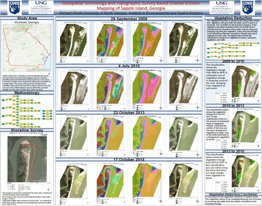
The data obtained for this project was National Agriculture Imagery Program (NAIP) 1m resolution imageries of 2009, 2010, 2013, and 2015. The automated geospatial model developed in ArcGIS ModelBuilder to classify imageries using the ISODATA-Maximum Likelihood Hybrid classification algorithm, as well as the Reclassify and Plus tool. The object of interest that was classified throughout the years was the vegetation of Sapelo Island. The vegetation meant all trees that were is the area, not grass because that area is majority saltmarsh. By classifying the vegetation for each year we were able to display the change and reduction of the vegetation over time due to salt water intrusion. The coastal vegetation reduction is caused by the rising of the oceans tide. Freshwater wetland vegetation declines with salt (brackish) water intrusion, and perished later.
The correlation to the shoreline change is, if the vegetation line keeps receding further and further back it indicates that the shoreline/ ocean water must be rising and changing impacting the vegetation. Using landuse and land cover classifying methods we could classify each year’s coastal vegetation cover and retrieve a result. This study, with the use of NAIP imagery classification, reclassification, and visual study, helped us to delineate the shorelines of the Sapelo Island AOI with regards to coastal erosion. The landuse change analysis to determine coastline freshwater vegetation reduction in Sapelo Island provided insight or confirmation of coastal erosion. The vegetation observed to be changing/reducing over time due to incoming salt water from the ocean and explaining the shoreline change.
The final classified images were overlaid on a true color ultra-high resolution ESRI base map to estimate and compare the shoreline locations of the Island in last 7 years. Also, the 2009, 2010, 2013, and 2015 shoreline results were substantiated with survey data comprising of distance and direction. This study is being updated using the LiDAR data obtained from NOAA Coastal database inventory. This project would help coastal managers for decision support on coastal erosion monitoring.