An Analysis Of The Volumetric Growth Rate Of The Southern Recurved-Spit Complex of Assateague Island, Virginia From 1852 To 2017
Introduction
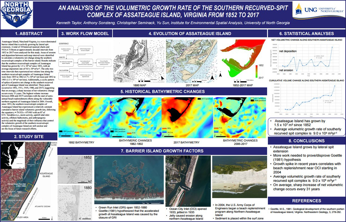
Assateague Island, MD-VA is a wave-dominated barrier island that is actively growing by southerly lateral-spit extension. Historical nautical charts show an abrupt increase in the southerly growth rate along Assateague Island beginning in 1880, forming the Toms Cove embayment. Goettle (1981) hypothesized that the rapid southerly growth of Assateague Island was linked to the closure to the updrift Green Run Inlet, which was open from 1852-1880, 20 km north of the southern recurved spit of Assateague Island. The Green Run Inlet would have intercepted sediment transported alongshore, thus starving the southern recurved spit of sediment. Upon closure of the Green Run Inlet, sediment was able to be freely transported to the southern recurved spit of Assateague Island. This study tests the Goettle (1981) hypothesis.
Authored by
Kenneth Taylor, Anthony Sonsteng, Christopher Seminack, & Yu Sun
Methods
A total of 17 historical nautical charts and NOAA T-Sheets at approximately decadal intervals from 1852 to 2017 were analyzed for this study. Historical maps and charts were georeferenced in order to digitize depth soundings and former shorelines. Areas of erosion and deposition between each map interval were identified to calculate a volumetric net change along the southern recurved-spit complex of the barrier island.
Results/Discussion
Results indicate that the southern recurved-spit complex of Assateague Island has grown by 1.5 x 10⁷ m3 since 1852, with an average deposition rate of 9.0 x 10⁴ m3yr-1. The only two time intervals that experienced net volume loss along the southern recurved-spit complex of Assateague Island were from 1855 to 1862 (2.7 x 10⁵ m3 net loss) and 1892 to 1901 (1.5 x 10⁶ m3 net loss).
Discussion
A cyclic pattern of spikes of positive net change in the southern recurved spit of Assateague Island were identified. These peaks occurred in 1892, 1911, 1949, 1980, and 2017; suggesting that on average, a sharp increase in net volumetric change occurs every 31 years. The sharpest increase in net volumetric change within the study period was observed between 2006 and 2017, where the southern recurved-spit complex of Assateague Island grew by 6.1 x 10⁶ m3. The volume increase between 2006 and 2017 correlates with the start of semi-annual beach replenishment efforts along the vulnerable northern segment of Assateague Island in 2004. Overall, since 1852, the southern recurved-spit complex of Assateague Island has experienced a relatively constant cumulative barrier island volumetric growth rate, following the equation y = 74352x - 671903 with an R2 of 0.91. Variables (i.e., storm activity, updrift tidal inlet activity, offshore bathymetry, and anthropogenic activity) and the magnitude of their influence that control the volumetric growth of the southern recurved-spit complex of Assateague Island are still unclear and are the focus of future research efforts.
Conclusions
The findings of this study did not provide definitive evidence to either confirm or deny the Goettle (1981) hypothesis. However, it appears that the growth of the southern recurved spit of Assateague Island occurs in cyclic pulses spanning 31 years on average. Additionally, more recent growth spikes correlate with beach replenishment adjacent to Ocean City Inlet, approximately 60 km to the north.
References
Goettle, M.S., 1981. Geological development of the southern portion of Assateague Island, Virginia. Northeastern Geology, 3, 278-282