Geospatial Modeling and Field Verification Approach for Watershed Based Decision Support System Design for Water Quality Improvement in Lake Lanier
Abstract:
Our study highlights the methods used to collect and build field data and sources used to retrieve available data along with procedures for data analysis and results exploration, highlighting the spatial aspect of land cover, soil, and slope towards the erosion and runoff contribution to stream health.
Authored by
Woody Depew, Margi Flood, & Sudhanshu Sekhar Panda
Background:
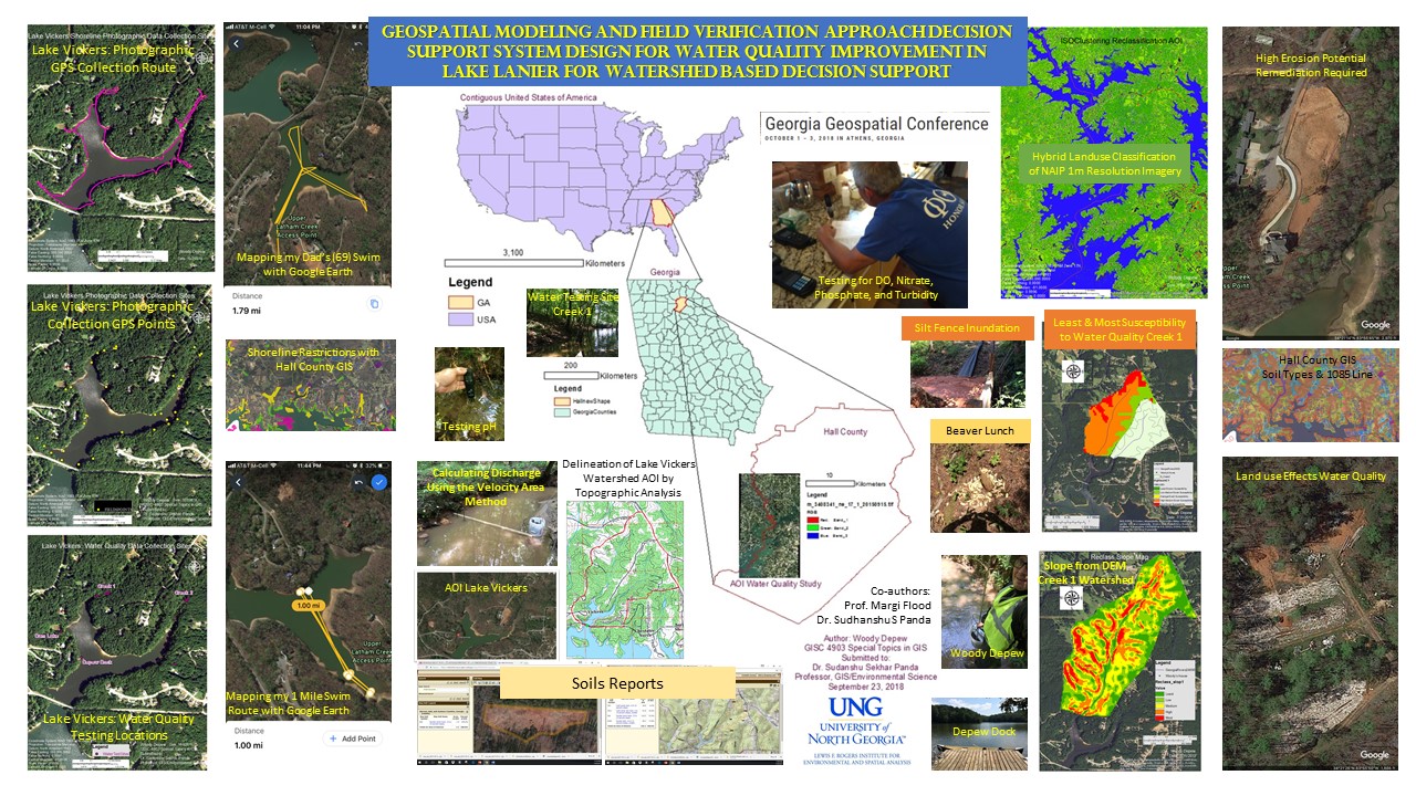
Lake Sidney Lanier is the drinking water source for more than 5.5 million Metro Atlanta residents and visited by 8 million people every year. Along with other advantageous contributions such as flood control, recreation, electricity generation, navigation, and pisciculture. Lake Sidney Lanier is valuable resource of both economic and intrinsic value.
Many small streams directly discharge to Lake Lanier. Some of the small streams contain retention ponds to obstruct silt deposition to Lake Lanier. This study completes a hydraulic analysis of a small watershed of 756 Acres with two constant streams, discharging into Lake Vickers, which is connected to Lake Lanier by underground culverts in Hall County Georgia.
Lake Vickers has been a training ground and recreational gem for the Depew family for over 30 years. As a family, we have organized serval clean-up efforts removing several tons of trash! As a student of UNG’s IESA program, I gained a greater appreciation for my abilities to model environmental factors that attribute to water quality and watershed health and set out to fully understand and analyze the watershed that provides wildlife, beautiful views, recreation, and, health to my family.
Methodology:
Background research was conducted through cited materials from google scholar to begin the process of evaluating small watersheds. The study time frame was July and August of 2017 and 2018. A comparison of base flow in 2017 and 2018 was conducted using the area-velocity method to calculate discharge. The precipitation data was collected from weather stations of the GA-AEMN (http://www.georgiaweather.net/) site and was analyzed for the study area.
Water quality testing was completed for both stream locations Creek 1 and Creek 2, Lake Vickers and a small pond in the greater Lake Vickers watershed. Runoff (discharge) and water quality correlation studies were completed through statistics software using multivariate regression technique. Water quality data used in this study are Nitrate, Phosphate, and DO, pH, temp, turbidity, electrical conductivity, date and time. Control study data for water quality was evaluated with water test results from Balus Creek at Old Flowery Branch Road and in Lake Lanier near the Flat Creek and Balus Creek exit points as well as rain and home tap water comparisons. Both watersheds and control areas were thoroughly groundtruthed, obtaining information on contaminant hotspots using photographic evidence and field notes preparation.
Results:
Hotspot sites were documented with photographs, geocoded, and mapped using Microsoft Excel and Arc GIS. We obtained detailed information on water contaminating hotspots in both watersheds and compared and contrasted them with watershed water quality results. The analyses were supported by NAIP imagery, SSURGO soil, and 3m DEM data.
Finally, the water contaminating hotspot land owners were ascertained from the Hall County parcel data and were informed about the misgivings. They were advised and offered help by the researchers to upgrade their land to reduce impact on the Lake Lanier reservoir water quality to which they are a partner too.